Datascape

The Desire project presents the digital engagement tool Our Walk App and datascape, how to use it, how to access the open source tool, etc.

Click on the box below with "Interactive datascapes" to go directly to the maps. In the bottom of the page you also find a link to a PDF explaining how to use the tool. And links to the dataspaces.

  • Our Walk App
  • Interactive datascapes

Our Walk App

The main intention of developing these tools is to help decision-makers, architects, urban designers and planners interactively explore the wishes and challenges of a local population in an area. Which things do people like, and what are they lacking? Which of these things do people agree on, and where is there high disagreement?

(01)
WHAT IS IT? - Our Walk App

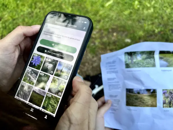
Our Walk App is a digital tool that enables participatory research about a place or a city under transformation. We use it to engage citizens, stakeholders and local communities in the data-collection, idea generation and co-design of cities and neighbourhoods.

In an engagement process, a group of locals join the app in a designated user group. All users of the same group are asked to complete one or more photo tasks. To complete a task participants go for a walk and take pictures of places and situations that are worth capturing or meaningful to them - in relation to the specific task they are given.

An example task could be: “Take photos of the things in your local area you like/dislike the most”.

To complete the photo task, the user is also asked to “annotate” the photo. This annotation can e.g. be a rating on how much they like/dislike the photo, or some text explaining why they chose their motive.

When photo tasks are completed, people have the opportunity to react to other users’ photos and give opinions on what they like/dislike about the motive other people have captured.

Requirements: In order to participate in an engagement round all users must have a smartphone (iPhone or Android) and be willing to enable sharing of their location data.

(02)
WHAT IS IT? The datascape

Our Walk app was originally developed as part of the Urban Belonging project at Aalborg University (read more here). The Desire project has contributed to the further development of the app and the data scape. The data scape is an interactive map representing the data collected through the Our Walk app. Specifically, the datascape displays all walks and photos taken with their exact geo-location.

The datascape aids decision-makers, architects, urban designers and planners to interactively explore the wishes and challenges of a local population in an area and thus supports the creation of urban spaces in which citizens feel seen, heard and listened to - and where they can see that their wishes have been taken into account.

(03)
HOW DO I USE IT? - The Datascape

The data displayed in the datascape can be filtered using the filters in the left panel. There are two types of filters:

1 - Annotation filters

The annotation filters enable the user of the datascape to investigate what the participants of the photo task wanted to emphasize when taking the picture. Participants can e.g. use tags (“nature”, “architecture” etc.) to tag what they are portraying. In the datascape the photos can then be filtered using these tags.

This knowledge can help urban planners investigate the area through the eyes of the locals; what do they value; what defines the local identity.

2 - Reaction filters

After task completion, participants react to each other's photos. The reaction filters in the datascape enable exploration of popularity (what is valued collectively by the community?) and agreement (does everyone agree that a specific thing in the urban environment is beautiful/important - or are there different opinions?)

This knowledge can help urban planners locate popular/unpopular aspects of the area as well as topics of debate that would be interesting to discuss further in a workshop.

(04)
WHERE HAS IT BEEN USED?

The app has been used at two different demonstration sites in the Desire project.

Falchera, Torino (Italy):

The aim of the project in Falchera was to conduct a series of workshops to investigate potentials and challenges of the area and with this provide input on how to rethink the programming and activities of the area. The aim of this project is to regenerate the area through circularity principles and reconnect people, especially the young generations, with natural spaces. In this project a group of young locals went on an urban exploration excursion through Falchera (Torino, Italy) among urban gardens and lakes, libraries etc. and took photos in the Our Walk app along the way of things they would like to preserve/reimagine when transforming the area.

You can explore the collected data by following this link.

Gadehavegaard, Høje Taastrup (Denmark):

The aim of the project in Gadehavegaard was to aid the developer Domea in transforming what is currently a massive parking lot in Gadehavegaard into a large green park area between 2027 and 2029. In this context, Domea wishes for youths who live there with their families to be the ones to create the vision for what the future green area should look like. In this project Our Walk app was used in an engagement process in which a large group of students and their teachers from Ole Rømer School. In the process the students completed multiple photo tasks, including a task related to what things they would like to preserve/reimagine in future Gadehavegaard.

You can explore the collected data by following this link.

(05)
HOW CAN I GET ACCESS TO THE TOOL?

This project is open source meaning that everyone interested are free to use the software. The design of the tasks in the Our Walk app and the filters in the datascape can easily be adapted to fit the context of a given urban development project. New users of the app and datascape can easily be granted access to set up their own tasks and design datascapes through a user friendly dashboard developed for this purpose.

If you wish to make use of the Our Walk App and the datascape, please contact VOLCANO:

Mail: INFO@VOLCANO.NU

(06)
HOW DO WE TAKE CARE OF YOUR DATA?

Information we collect

The Our Walk app stores your username and e-mail address when you register to do a photo task. When you use the app the information we collect is:

a) The images you take as well as their latitude and longitude (if you allow location permissions)
b) The annotations you make to your own and other’s pictures
c) Your route when you decide to do a photo walk

We have deliberately designed the location tracking in such a way that you are asked for permission to track you and the app only tracks you when you are in ‘walking mode’, i.e. it is only when you select the option to ‘go for a walk’ that location tracking is turned on. Every time you go on a walk you are notified that this is the case.

When taking photos of people an automatic blurring function is used to mask the face. In the case that the blurring is not complete, photos can be deleted manually immediately after collection in the Our Walk dashboard.

Data storage
The service securely stores your data in data centres within the EU, which is compliant with GDPR. Your personal data will not be transferred to third countries outside the EU or the EEA.

Our company does not transfer your personal data to a third party without asking for your consent, in a way that is clearly distinguishable from the basic uses of the app. Under specific circumstances and with reference to legislation, it might be necessary to transfer information to public authorities.

You can read the full description of how we take care of your data as well as your data protection rights in the Our Walk app privacy policy.

Visit the interactive datascapes

Click on the buttons below to explore the interactive maps from Cascina Falchera and Gadehavegaard.

Visit the interactive datascapes
PDF - OUR WALK APP, HOW TO?
The Desire project presents the digital engagement tool Our Walk App and datascape, how to use it, how to access the open source tool, etc. See the explanation.